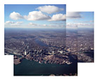
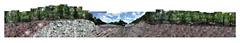
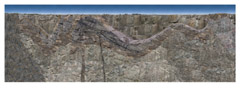
Landscape photography is a means to express my passion for exploring the earth’s surface and subsurface. The experiences leading up to this point include many trips traveling through the rural, mountainous areas of the northeast, studying the earth sciences of geology and hydrogeology, and working as an environmental consultant investigating and characterizing subsurface conditions at hazardous waste sites.
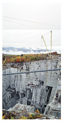
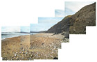
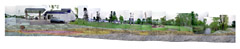
With my knowledge of geology, I have developed a project where I shift the viewer’s perspective to include both the landscape and a cross section of the earth below. The process involves photographing the land surface (along a stretch of land). The photographs are transferred to a digital environment where they are used to create a collaged panorama. Subsurface photographs are created by first studying the subsurface geologic framework, engineered installations, and/or human alterations. The sediment and rock types are photographed where they are exposed nearby and the engineered structures are photographed where representations are found above ground. This imagery is then joined to the surface panorama to form the final landscape panorama.
When looking at the landscape and what lies beneath, questions arise such as, how have we altered the land surface and subsurface during our time on earth? What is the relationship between the landscapes that we are familiar with above ground and the geology or environment below? So far, I have looked at areas such as cities, highways, quarries, and landfills. More specifically to my previous work, I have also looked at areas where we have contaminated the subsurface through use of petrochemicals and where we are working to clean up and/or prevent further spread of contamination.
- Jonathon Wells
 |
|
Click on each image for larger version and caption.

|